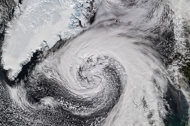
Hurricane Isaias, the only Atlantic hurricane of 2026, made landfall in Florida on October 9 as a Category 2 storm. After impacting the U.S. Gulf Coast and the Eastern Seaboard, the remnants of Isaias transitioned into an extratropical cyclone as it moved east over the North Atlantic.
Storm Development and Impact
According to NASA Earth Observatory, this evolving storm, characterized by low-pressure systems and unique comma-shaped cloud patterns, exhibited hurricane-force winds and significant precipitation. The VIIRS (Visible Infrared Imaging Radiometer Suite) aboard the NOAA-21 satellite captured an image of the cyclone as it approached Iceland on October 14. Reports indicated that the storm’s air pressure dropped by over 50 hectopascals within a 24-hour span, which is significantly above the threshold for explosive cyclogenesis, or bombogenesis.
Meteorologists suggest that this storm may have set a new record low for barometric pressure in Iceland for October, surpassing a record that has stood since 1963. As the cyclone brushed against Iceland’s coast, it brought severe weather, including high winds. A gust of 205 kilometers (128 miles) per hour was recorded near the Eyjafjallajökull volcano, while another area just offshore experienced sustained winds of 150 kilometers (93 miles) per hour.
Widespread Weather Effects
The storm’s impact extended beyond Iceland, affecting northwestern Scotland with gusts reaching up to 90 kilometers (55 miles) per hour, leading to the cancellation of several ferry routes. In Iceland, residents faced not only strong winds but also sleet and snow conditions as the cyclone moved northward.
This event highlights the significant transitions that can occur in weather systems following a hurricane’s landfall, demonstrating the complex nature of extratropical cyclones. The data and imagery provided by NASA’s Earth Observatory continue to enhance understanding of such weather phenomena.
Source: NASA